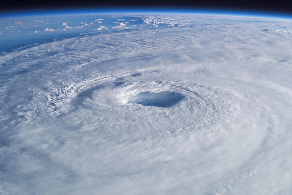
When Hurricane Melissa made landfall in Jamaica as a Category 5 storm, it became the strongest hurricane on record to strike the island. The storm’s combination of slow movement and extreme intensity brought devastating winds and rainfall across parts of the Caribbean, raising new questions about how such powerful systems form and behave.
To help make sense of what happened, we spoke with Deanna Hence, an atmospheric scientist and professor in the department of Climate, Meteorology & Atmospheric Sciences at the University of Illinois Urbana-Champaign. Before joining the Illinois faculty, Hence was a postdoctoral researcher at NASA’s Goddard Space Flight Center, where she studied tropical cyclones using the NASA Global Hawk research aircraft. Her current research focuses on tropical meteorology, the impacts of hazardous weather, and the application of radar and satellite data to enhance understanding of severe storms.
Let’s start with the basics. What can you tell us about Hurricane Melissa — when did it form, and what made it stand out compared to other storms this season?
Like many hurricanes, Hurricane Melissa began as a disturbance on the other side of the Atlantic Ocean around Oct. 16. Still, conditions weren’t right for it to develop into a full-blown tropical storm until it reached the Caribbean Sea on Oct. 19. Melissa then meandered in the center of the Caribbean until it made landfall as a powerful Category 5 storm in Jamaica on Oct. 28.
Where a storm goes is largely determined by the large currents of air flowing in our atmosphere: strong currents, such as the jet stream, will push it along, while weak currents, like a high-pressure region, can cause a storm to meander. What stood out about this storm as it developed was that it meandered for several days because the winds that help steer the storm were incredibly weak. This weak steering flow created the large uncertainty of where the storm would go, which left every landmass surrounding the basin wondering what it would do next. What we did know was that the other conditions for the storm to strengthen further were coming into place, so the storm would become a problem for whoever it happened to hit.
How are hurricanes predicted? How do we determine their path, and how intense they are going to be?
Meteorologists, and hurricane specialists in particular, use a suite of observations, statistics, and numerical simulations to predict where a storm will form, where it will go, and how intense it will be. Since hurricanes spend most of their time over water, a combination of satellite observations and hurricane surveillance flights helps ground our forecast models, improving their accuracy.
As predicting the behavior of the larger atmosphere has become increasingly accurate over the years, so too has predicting the steering flow and where a storm will go. However, hurricanes get their strength from harnessing the energy from warm ocean water and moist air, which feeds motions within massive clouds that condense huge amounts of rainfall. There are still many challenges in predicting these internal processes that affect hurricane intensity, especially those that lead to a storm rapidly intensifying.
Hurricane Melissa has been described as both unusually slow-moving and unusually intense. What factors contributed to that combination?
There are a few conditions that, when they come together, can help a storm to intensify rapidly. First, a deep source of very warm water, both at the surface and in the ocean depths, is where the hurricane gets its energy. Second, the air above the ocean needs to have plenty of moisture to help cloud formation. Third is favorable winds from the larger atmosphere; hurricanes like to build incredibly tall clouds, and they don’t like it if the winds at the top of those clouds are very different than those at the bottom, known as wind shear. If the wind shear is low, those clouds can build vertically in a way that enables the hurricane to utilize that energy most efficiently.
Melissa had plenty of energy to work with once it reached the very warm Caribbean Sea, but struggled with higher wind shear and dry air earlier in life. Forecasters observed that once the wind shear decreased and more moisture became available, the storm could suddenly organize itself more effectively to utilize that energy. The forecasting challenge is figuring out exactly when and how quickly a storm will do that; forecasters saw the likelihood Melissa would undergo rapid intensification as early as Oct. 23, but it is always a particularly dangerous situation when storms do this so close to land.
What differentiates a Category 4 hurricane from a Category 5? Do those categories reflect only wind speed, or are there other factors scientists look at to assess a storm’s potential impact?
The level of expected wind damage is based on the estimated maximum sustained winds, not short-burst wind gusts, which are typically close to the storm’s center. These wind speeds are estimated either by satellite presentation of the storm when it is far out to sea or by measurements taken by hurricane surveillance flights when the storm is closer to land. However, it is important to keep in mind that other impacts, such as storm surge (related to the wind speed and direction), heavy precipitation, and tornadoes spawned within the hurricane rainbands, pose their own threats that are not accounted for within this intensity scale. It is also important to remember that these other impacts can extend hundreds of kilometers away from the storm’s most intense core. When assessing a storm’s impact, all these potential hazards must be accounted for.
What kind of weather patterns or risks typically follow after a major hurricane like this one?
There are several risks that people can be left vulnerable to after a major hurricane. Follow-on storms can further damage buildings that have lost roofs or windows or blow around debris left from the hurricane. Given that power is often knocked out, people can be vulnerable to extreme temperatures if they are unable to access air conditioning or heat. Food or medication spoilage can become a problem without access to refrigeration. Flooding can contaminate drinking water and leave people wading through water contaminated with chemicals or sewage, leading to illnesses. Stagnant water can also breed mosquitoes that also spread diseases. The ability to respond to follow-on hazards of any kind can be severely impacted by the destruction to infrastructure, which can take months or years to rebuild.